1st US Road Trip, Texas - New Mexico - Arizona - Utah - Colorado : August, 2012 (Summer to Fall season)
Our first road trip was decided to go to some of famous National Parks using full size sedan car (Chevy Impala) in Arizona, Utah and Southwest Colorado, such as Grand Canyon, Bryce Canyon, Capitol Reef, Zion, Canyonlands, Arches, Monument Valley, and Mesaverde National Parks, and the bonus of this trip was that we spent two days in Las Vegas, Nevada for shopping and enjoy the night life. Just because we live in Houston, Texas, we begin our road trip from South to Northwest : Houston (TX) - Amarillo (TX) - Albuquerque (New Mexico) - Kayenta (Arizona) - Page (AZ) - Grand Canyon NP (Desert/East Entrance, AZ) - Flagstaff (AZ) - Las Vegas (NV) - Zion NP (UT) - Bryce Canyon NP (UT) - Capitol Reef NP (UT) - Canyon Land NP (AZ) - Arches NP (AZ) - Mesaverde NP (CO) - Go back Houston :). Total distance is vv 3813 miles (62 hours driving if non stop)
 |
| Our 1st road trip itineary (source: google maps) |
Day 1 : Houston (TX) - Amarillo (TX) - Tucumcari (NM)
We spent almost a half day just driving from Houston via Interstate 45 North - Highway 287 - I 40 West to a small city as a border between Texas and New Mexico states. :). Before we stay a night in Tucumcari (NM), we had a chance to see and take some pictures in one of famous place that it is called "Cadillac Ranch". This Cadillac Ranch is standing along Route 66 west of Amarillo, Texas, as an aristocracy of roadside attractions has been raised over the years These Great Monuments, we are told, represent America's hopes and dreams, art and commerce, materialism and spiritualism, folly and fame. Cadillac Ranch was invented and built by a group of art-hippies imported from San Francisco. Tourists are always welcome at Cadillac Ranch. If you bring spray paint, make sure to also bring a camera. Because whatever you create at Cadillac Ranch will probably only last a few hours before it's created over by someone else.
 |
| Cadillac Ranch, Amarillo, Texas |
 |
| My Wife and My Son in Cadillac Ranch, Amarillo, Texas |
Day 2 : Tucumcari (NM) - Kayenta (AZ) - Monument Valley Navajo Tribal Park (AZ)
Before we drive, we spent an hour to see around Tucumcary city because it has been a popular stop for cross-country travelers on Interstate 40 (formerly U.S. Route 66 in the area). It is the largest city on the highway between Amarillo, Texas and Albuquerque, New Mexico. Billboards reading "TUCUMCARI TONITE!" placed along I-40 for many miles to the east and west of the town invite motorists to stay the night in one of Tucumcari's campaign.
 |
| Left: A painted wall shows a legendary route 66 in Tucumcari; Right: At intersection of legendary Route 66 in Tucumcari Roads |
We started to drive from the hotel (Days Inn Tucumcari) around 8 AM (AZ time). In lunch time, we stopped by in Old and Historic town, Albuqueque, New Mexico. Then we continued our road trip to Arizona because we want to see sunset over Monument Valley Navajo Tribal Park, Arizona (we want to be experiencing one of the most majestic - and most photographed - points on earth).
 |
| Left: At San Felipe De Neri Church, Right: At Park with two native kids in Old Historic Town, Albuquerque, New Mexico |
 |
| Leaving Albuquerque, Heading to Northwest :) |
It was 5 hours driving from Albuquerque, then we checked in the Kayenta Monument Valley Inn which was near to the monument parks (30 minutes driving to the park). We were amazed with the view and the sunset moment there. This great valley boasts sandstone masterpieces that tower at heights of 400 to 1,000 feet. framed by scenic clouds casting shadows that graciously roam the desert floor. The angle of the sun accents these graceful formations, providing scenery that is simply spellbinding.The landscape overwhelms, not just by its beauty but also by its size. The fragile pinnacles of rock are surrounded by miles of mesas and buttes, shrubs, trees and windblown sand, all comprising the magnificent colors of the valley. All of this harmoniously combines to make Monument Valley a truly wondrous experience.
 |
With my lovely family in Monument Valley Navajo Tribal Park, Arizona
|
Day 3 : Monument Valley Navajo Tribal Park (AZ) - Page (AZ) - Lake Powell National Park (AZ) - Horse Shoe Bend State Park (AZ) - Grand Canyon National Park (AZ) - Las Vegas (NV)
Right after I took sunrise moment in Monument Valley at 6 am in the morning (what an amazing sunrise at that time, thanks God), I picked my family up in the Hotel to start another journey to other locations which are Lake Powell NP, Horse Shoe Bend State Park, and Grand Canyon National Park.
 |
| Sunrise Over Monument Valley Navajo Tribal Park, Kayenta, Arizona |
 |
| Panoramic View of Monument Valley Navajo Tribal Park in the morning, Kayenta, Arizona |
First stop is lunch time in Page (small city), Arizona which is nearest city to Lake Powell NP (5-10 mins driving). We just took some family pictures in one view point of Lake Powell/Glen Canyon Dam but we did not have a chance to go to the Lake due to time limitations :).
 |
| Left: My Wife and My Son at Glen Canyon - Lake Powell Dam |
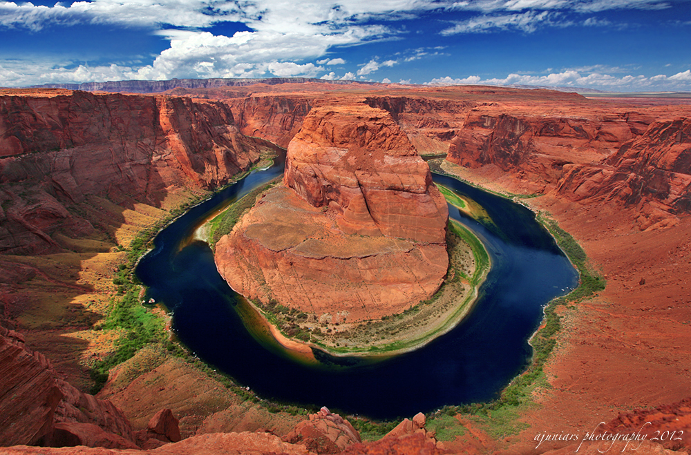
Second stop is Horse Shoe Bend National Military Park around 1 pm. Horseshoe Bend is the name for a horseshoe-shaped meander of the Colorado River located Southwest near to the town of Page, Arizona, in the United States. It is located 5 miles (8.0 km) downstream from the Glen Canyon Dam and Lake Powell. The Horseshoe Bend parking lot is located 4 miles south of the Glen Canyon dam on the west side. The hiking sign is small and easy to miss, but the parking lot is easy to see from the road. Hike west 3/4 of the mile over loose sand and Navajo sandstone and you will be at the edge. Due to summer season and too hot to hike, my wife and my son stayed in the car, and I hiked to see this geological feature as product of meander river. When I reach the edge of Horseshoe Bend I was amazed to look down 1000 feet ( 305 meters) of the sandstone to the river. After the Navajo Sandstone hardened, other layers of sandstone, mudstone, and different sedimentary layers piled on top of it.
 |
| Horse Shoe Bend bird view, Page, Utah |
Just spent 30 minutes in Horse Shoe Bend for taking some amazing pics, we continued our road trip directly to magnificent Grand Canyon National Park, and I planned to go to East entrance (Desert View) instead of South entrance because it was the fastest time to be there about 3 hours driving, and 8 years ago I was in South entrance. Just curious the view from this overlook point of view.
 |
| At Desert View, East Entrance, Grand Canyon National Park, Arizona |
Grand Canyon National Park is the United States' 15th oldest national park. Named a UNESCO World Heritage Site in 1979, the park is located in Arizona. The park's central feature is the Grand Canyon, a gorge of the Colorado River, which is often considered one of the Seven Natural Wonders of the World (wikipedia). In geological point of view, the Grand Canyon, including its extensive system of tributary canyons, is valued for its combination of size, depth, and exposed layers of colorful rocks dating back to Precambrian times. The canyon itself was created by the incision of the Colorado River and its tributaries after the Colorado Plateau was uplifted, causing the Colorado River system to develop along its present path.
 |
| Desert View Over Look at East Rim of Grand Canyon National Park |
We just spent 2 hours to stop here because right after I took the pic above, the rain started to fall. I was a quite disappointing because my plan to take a sunset moment, was ruined by heavy rain. Thus, we decided to continue our road trip direct to Las Vegas, Nevada. On the way going to Las Vegas, I stopped in a small road to take sunset pictures somewhere in the road of Interstate 40 west (see pic below). It was beautiful sunset.
 |
| Sunset in somewhere along I-40 West about 40 miles before Las Vegas |
It was about 4 hours driving to our Hotel, Hard Rock Hotel, Las Vegas :). And fortunately, no rain was in Las Vegas at that nite. My family was excited to see the night lights of Casino from our car.
 |
| At Hard Rock Hotel and Casino, Outside and Inside the room :) |
Day 4 : Las Vegas (NV) - Hoover Dam (NV) - Lake Meadow National Recreational Area (NV) - Las Vegas (NV)
In this day 4 of our trip, we just wanted to stay and enjoy the Las Vegas and surrounding area such as Hoover Dam as one of the biggest Dam in the United States and Lake Mead near to Hoover Dam including bag shopping for my wife and watching the Night City Lights including dance water fountain lights in front of Bellagio Hotel, Las Vegas:).
In the morning till lunch time, we decided to go to Hoover Dam and Lake Meadow National Recreation Area.Hoover Dam, once known as Boulder Dam, is a concrete arch-gravity dam in the Black Canyon of the Colorado River, on the border between the US states of Arizona and Nevada. It was constructed between 1931 and 1936 during the Great Depression and was dedicated on September 30, 1935, by President Franklin D. Roosevelt.
tes
 |
| Hoover Dam, Nevada |
We just spent 1.5 hours in Hoover Dam just looking around, then we continue to Lake Mead overlook spot from above (just 5 minutes driving from Hoover Dam).
 |
| Entrance Gate and Aerial Overlook Lake Mead National Recreation Area, Nevada |
After having lunch, we went back to Las Vegas for shopping window and enjoy the nite citylights :). We parked our car in parking lot of New York Hotel, then we just walked thru the Las Vegas boulevard to see casinos, lights, etc.
 |
| Left: In the front of New York Hotel and Casino, Right: At Harley Davidson store, Las Vegas |
 |
| A blue hour time in Bellagio Hotel pool while waiting on Water Dancing |
video of water fountain dancing will be added
Day 5 : Las Vegas (NV) - Zion National Park (UT) - Bryce Canyon National Park (UT)
Before we drive to the North, I decided to take family photo in some part of Las Vegas boulevard and famous sign of Welcome to Las Vegas :). We wish that we can stay longer than 2 days in Las Vegas :), because of vacation time limitation, we continue our day 5 road trip to the North via I-15 N and Highway 9.
 |
| Popular sign of "Welcome to Fabulous Las Vegas, Nevada" |
3 hours driving was my time to drive from Las Vegas to Zion National Park, Utah. When we were entering the road 9, We were amazed by landscape view because we can enjoy the great red rocks view along the road.
 |
| Springdale Canyon, Zion National Park, Utah |
The Zion National park is located in southwestern Utah in Washington, Iron, and Kane counties. Geomorphically, it is located on the Markagunt and Kolob plateaus, at the intersection of three North American geographic provinces: the Colorado Plateaus, the Great Basin, and the Mojave Desert.
 |
| At Zion National Park, Utah |
2 hours is the maximum time we spent in Zion, because I planned to have sunset time in Bryce Canyon National Park at the northern part of Zion (about 1 hour 30 mins). Bryce Canyon National Park is a national park located in southwestern Utah in the United States. The major feature of the park is Bryce Canyon, which despite its name, is not a canyon but a collection of giant natural amphitheaters along the eastern side of the Paunsaugunt Plateau. Bryce is distinctive due to geological structures called hoodoos, formed by frost weathering and stream erosion of the river and lake bed sedimentary rocks. The red, orange, and white colors of the rocks provide spectacular views for park visitors.
 |
| At Entrance Gate and Main Overlook Bryce Canyon National Park, Utah |
Thanks God again, I got a beautiful sunset moment in Bryce Point at Bryce Canyon National Park. It was incredible to take sunset photo here. This point is extended version of Bryce Canyon overlook, you can see an entire Bryce Canyon from this point of view.
 |
| Beautiful Sunset at Main Overlook, Bryce Canyon National Park, Utah |
We'd enjoyed the view until sun going down in this point around 8 PM. I bet I will go this place again someday :), what an incredible view here. Then we continued our trip to the hotel (Best Western Resort Capitol Reef Hotel - 1 hour from Bryce Canyon) in between Bryce Canyon NP and Capitol Reef NP as our destiny tomorrow morning.
Day 6 : Capitol Reef National Park (UT) - Canyonlands National Park (UT) - Arches National Park (UT) - Moab (UT)
When I woke up in the morning at the Hotel, I did not realized that the room had a great view in the back. I was amazed when I was looking at the view of first sunlight covers the red hills from the room's balcony. If you are looking for the hotel between Bryce Canyon NP and Capitol reef NP, this hotel is highly recommended by me :)
 |
| Back view from the Hotel's balcony in the morning |
After having breakfast in the hotel, we prepared to go directly to Capitol Reef National Park. Another red rocks formation was awaited from us :). Just take 30 minutes driving, you will see the entrance sign to Capitol Reef National Park.
 |
| Stopped at Entrance Gate with beautiful scenic drive to the West |
Right after we stopped by at entrance sign, there were 2 spots that we stopped for taking some pictures of gorgeous stone formations which are twin rocks and chimney rocks as you can see in the pictures below. We drove along scenic drive of Red Rock Formations before we stopped by in visitor center.
 |
| Left: Posing at Twin Rocks :), Right : Chimney Rocks at Capitol Reef National Park, Utah |
Just spent 2 hours in Park Visitor Center and took some picture surrounding this Park. Capitol Reef National Park is a United States National Park, in south-central Utah. Capitol Reef National Park protects colorful canyons, ridges, buttes, and monoliths. "Capitol Reef" is the name of an especially rugged and spectacular segment of the Waterpocket Fold near the Fremont River.
 |
| Left: Capitol Reef formation view from visitor center, Right : Another Chimney Rocks outcrop in Capitol Reef NP |
Just drive to the East of visitor center, we saw a house what they call as Fruita School House. The Fruita School house was built in 1896 on land donated by Elijah Behunin, who built the one-room log schoolhouse. His twelve year old daughter Nettie was the first schoolteacher. 3 miles to the East, we saw another great formation of dome rocks. They called as Navajo Dome.
 |
| Left: Fruita School House, Right: Navajo Dome Formation, Capitol Reef National Park |
After we stopped by in the dome rocks, we continued our road trip to Canyonlands National Park and Arches National Parks. We drove along Highway 24 - Interstate 70 East - Highway 191. You could see a lot of kind of rock formations along Highway 24 before you reach I-70.
 |
| Some interesting rock formations in a sand desert along HWY 24 |
It was 3 hours driving from Capitol Reef to Canyonlands. Canyonlands National Park is a U.S. National Park located in southeastern Utah near the town of Moab and preserves a colorful landscape eroded into countless canyons, mesas and buttes by the Colorado River, the Green River, and their respective tributaries.
 |
| Left : Entrance Gate Canyonlands NP, Right : One of Interesting point in Canyonlands NP : Monitor & Merrimac Rocks |
In geological perspective, Canyonlands is a subsiding basin and nearby uplifting mountain range (the Uncompahgre) existed in the area in Pennsylvanian time. Seawater trapped in the subsiding basin created thick evaporite deposits by Mid Pennsylvanian. This, along with eroded material from the nearby mountain range, become the Paradox Formation, itself a part of the Hermosa Group.
 |
| An Overlook of Canyonlands National Park, Utah |
One of the most popular eroded stone site is Mesa Arch in this National Park. I stopped by and hiked about 0.75 miles to reach this arch for taking some shoots of this unique geological rocks.
 |
| Mesa Arch in right and front views show an unique eroded rock formations |
After Mesa Arch point, I decided to go to Grand View Point as popular point to see the canyon lands from aerial point of view. We decided not to spend too much time in this Canyonlands, because my plan was enjoying the sunset in the Arches Park National Park which is 10 miles to the East from this place.
 |
| With my lovely Family at Grand View, Canyonlands NP, Utah |
 |
| Left: Grand View Point, Right: Green River Overlook, Canyonlands National Park, Utah |
Just 15 minutes from Canyonlands, we arrived in Arches National Park Gate. As usual, we posed in the entrance sign :). Arches National Park is a U.S. National Park in eastern Utah. It is known for preserving over 2000 natural sandstone arches, including the world-famous Delicate Arch, in addition to a variety of unique geological resources and formations.
 |
| Left : At Arches National Park Entrance, Right : Scenic drive show Organ Tower on the right and Three Gossip Tower from far away on the left. |
The national park lies atop an underground evaporite layer or salt bed, which is the main cause of the formation of the arches, spires, balanced rocks, sandstone fins, and eroded monoliths in the area. This salt bed is thousands of feet thick in places, and was deposited in the Paradox Basin of the Colorado Plateau some 300 million years ago when a sea flowed into the region and eventually evaporated.
 |
| Natural Arches and Sandstone Formations lie along Arches National Park, Utah |
One of great and easy point of view to reach is the Balanced Rock because it is located near to parking lot. You could see directly the rocks from the parking lot without any hiking :).
 |
| Left : At Court Tower Rock, Right : My wife at "Balanced Rocks", My Son slept in the car :) |
 |
| Closer look of Balanced Rocks in Arches National Park |
Right after we stopped in this Balanced Rocks point of view, I decided to go to the greatest and the most famous Arch in this National Park which is "Delicate Arch". I need to have a closer look of a sunset moment in the Arch :). First, we drove to lower point of view which is easy to reach because near to parking lot.
 |
| Lower point of view of Delicate Arch, Arches National Park |
Then after we finished to take some shoots from Lower Point, I drove to parking lot that has a hiking pathway to Delicate Arch. Delicate Arch is probably the most photographed arch in the world. My dream came true, I could see closely of this Arch. Thanks God. Although my wife and my son waited for me in the car. I wish I could bring my family here someday.The hike is an easy hike if it is treated as such. The trail is heavily traveled and well defined. It is about 1.5 miles hike and need about 1 hour to hike from parking lot to the Upper point of Arch.
 |
| Right after sunset and waiting on blue hour with some people behind in Delicate Arch :) |
The original sandstone fin was gradually worn away by weathering and erosion, leaving the arch. Resting on top of a huge Entrada Sandstone formation, the world-famous site offers a dramatic views. I enjoyed the view about 1 hour until blue hour time here.
 |
| An amazing Delicate Arch on Sunset and Blue Hour time with different angle of view |
Because it was already dark and we were tired for this trip, we decided to stay a nite in Moab (nearest city from Arches NP, about 30 mins driving).
Day 7 : Moab (UT) - Durango (CO) - Mesaverde National Park (CO) - Albuqueque (New Mexico)
Started at 7 a.m. in the morning, we drove to Durango as a one of historical city in Colorado. 3 hours driving was needed to reach the downtown of Durango. We spent 1 hours to walk around in the downtown and had some breakfast there. It was nice and classic city.
 |
| My wife and My son enjoy the downtown Durango in the morning, Colorado |
Unfortunately one of attractions in Durango which is an old train tour, was being under maintenance at that time, so we just continued our trip to Mesaverde National Park, which is located only 36 miles from Durango (40 minutes driving). Mesa Verde National Park is a U.S. National Park and UNESCO World Heritage Site located in Montezuma County, Colorado, United States. It is the largest archaeological preserve in the United States.
 |
| At Mesaverde National Park Entrance Gate |
Mesa Verde National Park's canyons were created by erosion from receding ancient oceans and waterways, which resulted in Mesa Verde National Park elevations ranging from about 6,000 to 8,572 feet (1,800 to 2,613 m), the highest elevation at Park Point. The terrain in the park is now a transition zone between the low desert plateaus and the Rocky Mountains
 |
| At Park Point, the Highest Point in Mesaverde National Park. Elevation 8572 feet |
From the Park Point (the highest point in Mesaverde NP), we drove to famous well-preserved cliff dwellings such as the great cliff palace. Need 40 minutes driving to go to this palace.
 |
| At Cliff palace Overlook Point, Mesaverde National Park, CO |
Mesa Verde is best known for a large number of well-preserved cliff dwellings, houses built in shallow caves and under rock overhangs along the canyon walls. The structures contained within these alcoves were mostly blocks of hard sandstone, held together and plastered with adobe mortar.
 |
| Left: Cliff Palace, Right: Spruce Tree House, Mesaverde National Park, Colorado |
3 hours we spent our time in Mesaverde, then we'd continued our road trip for 4 hours driving to stay a nite in Quality Inn, Alburqueque, New Mexico, on the way go back home in Houston.
Day 8 : Albuqueque (New Mexico) - Amarillo (Texas) - Houston (Texas)
After having breakfast in the morning, we want to visit Hard Rock cafe Albuqueque, New Mexico for buying some souvenirs :) before we go back to Houston.
 |
| In Hard Rock cafe Albuquerque, New Mexico |
Then Going Homee to Houston.. To be continued in 2nd Road Trip (Colorful and First Snow in some National Parks, Fall Season Trip) in Colorado (Garden of the Gods State Park, Rocky Mountain National Park, Aspen, Maroon Bells State Park) - Wyoming (Grand Teton and Yellowstone National Park) - Montana (Glacier National Park) - South Dakota (Mount Rushmoore National Monument) - Nebraska (Chardon State Park).. :)
to be continued...


Tidak ada komentar:
Posting Komentar